
John Allen seeks to find photographers with images of the Brenva Face taken over the previous twenty five or so years for an important environmental project. Can you help him?
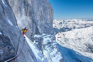
In the Mont Blanc region of the Alps, climate change is having a marked effect on the choices made by climbers and mountaineers when selecting a route suitable for individual inclinations. The retreat of glaciers (e.g. Mer de Glace, Glacier de la Brenva), rock falls and collapses of séracs, and increases in summer-time temperatures (e.g. freezing level regularly above 4000m) have created new and sometimes unwelcome changes to ground conditions for climbers. Access routes to established climbs have become more dangerous from falling debris, as evidenced on the Brenva Face. Weakened permafrost may have contributed to rock falls above Col Moore and also nearby with the collapse of the Bonatti Pillar of the Dru in 2005 and the rock avalanche on the east face of the Tour Ronde in 2015.

© John Allen
Photography project: a key to recording climate change as it affects routes
Firstly, I am not a scientist and do not seek to make an exhaustive scientific survey. Secondly, I have been an enthusiastic photographer and mountaineer all my life and wish to put my library of photos to good use before it is too late and they get thrown out with my ashes.
Project aims, objectives and methods
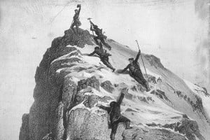
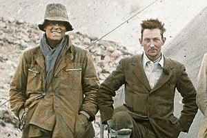
Beginning with the existing photographic record made by Professor T Graham Brown in the period 1927 – 1933 (his Brenva period), I want to create a comparative photographic record of ground conditions affecting mountaineering routes on the Brenva Face of Mont Blanc that shows similarities and differences through the last hundred years.
Using TG Brown's photos as a baseline, I want to compare and contrast later photographs that show erosion suspected to be the result of climate change.
By fixing an approximately 25/35 year period between eras of similar duration, it should be possible to spot similarities and differences of ground conditions that affect climbing possibilities and options affecting climbers when planning for routes within their potential.
By using my active period (1965 – 1975) of mountaineering I can offer a reasonable selection of photographs taken on major routes on the Brenva Face and environs at that time. I was heavily influenced by Graham Brown's book 'Brenva' (published in 1944).
Other contributions from a period, say 1995 to the present day, would also be welcome, preferably from climbers who have made a few visits to this area generally, and specifically to routes actually climbed on the Brenva Face with resulting photographs.
However more importantly, is there anyone out there who has made a specific photographic record of their climbs on and around the Brenva face in the last 25 years from approximately 1995? New photos could update previous photo records showing changes of ground conditions. For guidance here, route photos would be valuable but also general location and scenic photos at the time, and other times, and to indicate how the approach routes to climbs have changed. Landscape photos including glaciers, crevasses, bergschrunds, seracs and rock buttresses would also contribute to a fulsome record. Is there anyone out there with a range of photos?
Suitable viewpoints for the Brenva Face routes would be the summit of the Tour Ronde, the Aiguille de la Brenva, the Brenva glacier, the Aiguille Noire de Peuterey and maybe other viewpoints that I have not visited and look into the Brenva Face. Both wide angle and telephoto shots would add to the coverage of specific detail (eg the Sentinel rock, and 1997 rockfall near Col Moore). In fact, might someone even consider the whole idea as a major personal photographic project?
I have recently examined the Brenva Face via Google Earth and noticed that it seems to have changed radically since the 1970s, which then was not greatly different from the late 1920s/early 1930s of TGB's day. The present evidence of rock/ice avalanches below the Great Couloir and disappearance of the ice cliffs from beside the top of the Pear and the top of Route Major makes for a new topography. The Pear now looks more like a swollen gherkin than a pear, appearing slimmed down and elongated.
If you have any information or suggestions to contribute, please contact John Allen: hillandben @ outlook.com


Comments
Can do, but you need to close hillandben @ outlook.com to hillandben@outlook.com in your email connection because it won't work as it is!
From Summer 1991. Just quickly took these images of photos in an old album. If of interest, can take more carefully.
https://www.dropbox.com/sh/g96ec0j6be5icnh/AADQigglaJufIioQB0bm4X7ga?dl=0
I did that deliberately to stop spammers.
*of the robotic kind.
Looking at the 7/13/2015 imagery. Good grief it's bare. The bottom of the Brenva ridge looks like a rubble choss-fest.
Definitely no summer routes any more.
My word - hair! Will need to find my negatives and scan those ....