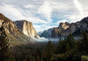
The Cross Borders Drove is a rambling trail that follows the paths of old drovers as they transported their cattle from the Pentland Hills, to the market at Hawick. Classed as one of Scotland's Great Trails, it sees suprisingly little traffic, but don't let this put you off. The 52 mile journey takes you through towns, woodland, hills and farms, a bit of everything! It is perfect for taking your time over a few days and enjoying the changing scenery, but also makes a great challenge if you choose to take it on a bit faster. The route is signposted, however maps are compulsory as at times the signs are sparse.
Not official. Having actually just returned from doing Langholm to Hawick to ~Newcastleton and then down to Brampton, you definitely can do it with a tent.
A Hawick/Newcastleton/Langholm circular could actually be a very logical, impressive, long distance path.
Driving S from Newcastleton the accommodation gets tricky of course, we used the Crossings inn (maybe an old drovers thing) and a lot of small roads.
Thanks, but I'm not sure from your post - did you walk, cycle or drive your circuit? I've walked a little around Langholm and in the Craik Forest near Hawick but can't claim to know the area well myself.
Walked. The hills are mainly grassy and quite howgillish but far less short cropped, so harder going except when you hit ATV tracks. You'd need to camp somewhere on the way.
Hawick to Newcastleton is maybe the more logical of the two for a continuation. Checking Haldane today, the historic drove route used the Presithaugh valley and Swire Knowe to get S. That's a 450m col with easy gradients.
Sadly swallowed by pine trees. So we went up Skelfhill valley and over/down Tudhope hill - only a maniac would have tried to drive cattle down that slope
The historic droving routes from there also don't seem useful in the modern day, but there's a modern track based alternative to use into Newcastleton. Swing E a bit to go up Caulker grain and that track should go all the way to Newcastleton via a fine waterfall or two.
We tried swinging round over Cooms fell/Tinnis hill instead from the trig but I'd be cautious - much harder going.
Then for further S, the old railway helps a bit, yellow roads etc. You could likely get to Longtown from Newcastleton if aiming at Carlisle.
Thanks, that's a lot of useful detail. We used to get out in the Borders quite often, usually on the way to bag Munros or breaks in the Moffat area. Last year we were standing by the big monument (White Hill?) above Langholm looking north and thinking those hills resembled the Howgills.
Jobs Boulders Cheltenham - Duty Management and Setting roles
Elsewhere on the site
In Focus Red Snow at Height
Press Release Mick and Vic resume partnership to target a new unclimbed objective
Podcast Factor Two - S2 Ep.4: No More Worlds - Leo Houlding
Fri Night Vid The Crux - Behind the Scenes of IFSC Competitions
This week's Friday Night Video(s) is a deep dive into the IFSC competition scene in the run up to the Paris 2024 Olympic Games. National Geographic follow several athletes throughout the season through the ups and downs of competing...